


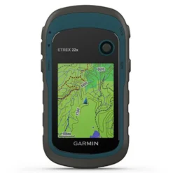


Garmin ETrex 22X GPS
Original price was: £168.99.£95.99Current price is: £95.99.
- Safe Payments, the Smart Choice
- Protecting Your Payment Information
- No-Questions-Asked Returns
- Get the Best for Less

Etrex 22x is a tracker created for hiking and cycling. This Garmin team offers the proper reading of maps and routes on its 2.2 ´´screen with 240 x 320 pixels.
To get to the desired destination, this team has TopoActive maps loaded. In addition, the device has compatibility with GPS and GLONASS satellites to facilitate tracking on a particular path, making it possible to find the most difficult environments. If you want to know more information, you can download maps and save them in an 8GB memory card that is inserted into the microSD slot. If you wish to have the Bird Eye satellite images, you should only request the additional subscription.
Its operating autonomy is 25 hours and they use two AA batteries. The installation of this device can be done in boats, bicycles, excursions and vehicles for all types of terrains, since these computers resist contact with water.
Explore confidently with the reliable handheld GPS:
– 2.2” sunlight-readable colour display with 240 x 320 display pixels for improved readability
– Preloaded with TopoActive Europe maps with routable roads and trails for cycling and hiking
– Support for GPS and GLONASS satellite systems allows for tracking in more challenging environments than GPS alone
– 8 GB of internal memory for map downloads plus a microSD™ card slot
– eTrex 32x adds a 3-axis compass and barometric altimeter
– Battery life: up to 25 hours in GPS mode with 2 AA batteries
eTrex 22x and eTrex 32x offer the same ease-of-use, durability and affordability that the eTrex handheld GPS series is known for — along with preloaded TopoActive Europe maps. These devices are perfect for quad bikes, bicycles, boats or hiking.
See the way:
– eTrex 22x and 32x offer enhanced 2.2”, 65K colour, sunlight-readable displays. Durable and water resistant, these handhelds are built to withstand the elements.
Explore the terrain:
– The eTrex 22x and 32x handheld devices come preloaded with road-routable TopoActive Europe maps that feature streets and trails so you can take the journey off the grid. Now you can know your surroundings — such as waterways, natural features as well as buildings, international boundaries and more. You can also find thousands of points of interests, including shops, restaurants, universities, car parks and accommodations.
Keep your fix:
– The eTrex series uses both GPS and GLONASS satellite systems so the receiver has the ability to track in more challenging environments than GPS alone. eTrex 32x adds a 3-axis compass and barometric altimeter, making it easy for you to keep your bearings.
Add maps:
– With a microSD card slot and expanded 8 GB of internal memory, you can easily download additional maps for wherever the adventure takes you.
Satellite imagery:
– Both devices support BirdsEye Satellite Imagery (subscription required), so you can download and integrate satellite imagery with your maps.
Find fun:
– eTrex 22x and eTrex 32x support paperless geocaching. Upload GPX files straight to your device, and view key information such as location, terrain and hints from Geocaching.com.
Go anywhere:
– With an array of compatible mounts, eTrex is designed as an outdoor handheld GPS ideal for use on quad bikes or bicycles, in boats or on foot. Use the auto mount capability and City Navigator® NT maps for turn-by-turn driving directions, or use the rugged mount for your motorcycle or quad bike. Wherever you think you might take eTrex, it has the mapping and mounts to get you there.
Specifications:
General:
– Physical dimensions: 5.4 x 10.3 x 3.3 cm
– Display size: 3.5 x 4.4 cm; 2.2´´ diag (5.6 cm)
– Display resolution: 240 x 320 pixels
– Display type: 2.2´´ transflective, 65K colour TFT
– Weight: 141.7 g (with batteries)
– Battery: 2 AA batteries (not included); NiMH or Lithium recommended
– Battery life: 25 hours
– Water rating: IPX7
– Memory/history: 8GB
– High-sensitivity receiver: Yes
– Interface: USB
Maps & memory:
– Preloaded maps: Yes (TopoActive Europe; routable)
– Ability to add maps: Yes
– Basemap: Yes
– Storage and power capacity: microSD™ card (not included)
– Waypoints/favourites/locations: 2000
– Routes: 200
– Track log: 10,000 points, 200 saved tracks
Outdoor recreation features:
– Area calculation: Yes
– Automatic routing (turn by turn routing on roads): Yes (with optional mapping for detailed roads)
– Geocaching-friendly: Yes (Paperless)
– Hunt/fish calendar: Yes
– Sun and moon information: Yes
– Picture viewer: Yes
IN THE BOX:
– eTrex 22x
– USB cable
– Documentation
| Size | One Size Dark Grey / Blue |
|---|---|
| Color | Blue |
| Features | GPS |
| Recommended Use | Hiking |
Be the first to review “Garmin ETrex 22X GPS”
Related products
Sunglasses
Sunglasses
Sunglasses
Sunglasses
Sunglasses


Sunglasses
Sunglasses

Sunglasses
Reviews
There are no reviews yet.