


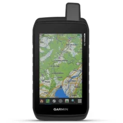


Garmin Montana 700 GPS
Original price was: £307.00.£95.99Current price is: £95.99.
- Safe Payments, the Smart Choice
- Protecting Your Payment Information
- No-Questions-Asked Returns
- Get the Best for Less

Explore Your World With Navigation You Trust:
– With routable mapping for roads and trails, the Montana 700 handheld brings advanced outdoor features into a sturdy 5” format that’s ideal for navigation on foot, bike, kayak, ATV and more.
– Expect big things. A large touchscreen puts them all at your fingertips.
– Routable TopoActive Europe maps. Now you’re free to take it off-road or on.
– Meets MIL-STD 810 for thermal, shock, water and vibration.
– Get the clear perspective of BirdsEye Satellite Imagery right to your device.
– Go far with no fear. ABC sensors and multiple GNSS networks have your back.
– Power your adventures with 18+ hours of lithium-ion battery life in GPS mode.
Track your adventures on any terrain:
Rugged By Design:
– This durable, water-resistant handheld is tested to U.S. military standards and features a glove-friendly 5” touchscreen that’s 50% larger than previous Montana models.
Topoactive Europe Maps:
– To navigate your adventures, use preloaded TopoActive Europe maps. View elevations, coastlines, rivers, landmarks and more.
Satellite Views:
– Use direct-to-device downloads of BirdsEye Satellite Imagery (no annual subscription required) to see photo-realistic views and create waypoints based on landmarks.
Abc Sensors:
– Navigate your next trail with ABC sensors, including an altimeter for elevation data, barometer to monitor weather and 3-axis electronic compass.
Active Weather:
– Use cellular connectivity1 to access up-to-date Active Weather forecasts through the Garmin Connect™ app.
Dog Tracking:
– This Montana syncs with compatible Atemos series handhelds (sold separately) to help track dogs in the field.
Take it hiking. Take it off-grid:
Multi-Gnss Support:
– Access to GPS, GLONASS and GALILEO satellite networks enables Montana® 700 to track in more challenging environments than GPS alone.
Location Sharing:
– The LiveTrack feature lets you wirelessly connect1 your device with other compatible Garmin GPS users, so they can follow your tracks, routes, waypoints and adventures.
Expedition Mode:
– Trek far and wide off-grid. Use Expedition mode, an ultralow-power GPS reference, to keep Montana tracking for a week or more between recharges.
Battery Options:
– An internal, rechargeable lithium-ion battery pack provides more than 18 hours of battery life in GPS mode. It can also be powered with traditional AA batteries.
Vehicle Mounts:
– A variety of Montana handheld-compatible mounts (sold separately) lets you adapt your navigator for use on ATVs, boats, cars, motorcycles, RVs or other vehicles.
Specifications:
General:
– Physical Dimensions: 8.76 X 18.30 X 3.27 Cm
– Touchscreen: Yes
– Display Size: 6.48 X 10.80 Cm; 5´´ Diag (12.70 Cm)
– Display Resolution: 480 X 800 Pixels
– Display Type: Wvga Transflective, Dual Orientation
– Weight: 397 G With Included Lithium-Ion Battery Pack
– Battery Type: Rechargeable Lithium-Ion (Included) Or 3 Aa Batteries (Not Included); Lithium Recommended
– Battery Life: Gps Mode: Up To 18 Hours
– Expedition Mode: Up To 330 Hours
– Water Rating: Ipx7
– Mil-Std-810: Yes (Thermal, Shock, Water, Vibe)
– High-Sensitivity Receiver: Yes
– Interface: High Speed Micro Usb And Nmea 0183 Compatible
– Memory/History: 16 Gb (User Space Varies Based On Included Mapping)
Maps & Memory:
– Preloaded Maps: Yes (Topoactive Europe)
– Ability To Add Maps: Yes
– Basemap: Yes
– Automatic Routing (Turn By Turn Routing On Roads) For Outdoor Activities: Yes (With Optional Mapping For Detailed Roads)
– Map Segments: 15000
– Birdseye: Yes (Direct To Device)
– Includes Detailed Hydrographic Features (Coastlines, Lake/River Shorelines, Wetlands And Perennial And Seasonal Streams): Yes
– Includes Searchable Points Of Interests (Parks, Campgrounds, Scenic Lookouts And Picnic Sites): Yes
– Displays National, State And Local Parks, Forests, And Wilderness Areas: Yes
– Storage And Power Capacity: Yes (32 Gb Max Microsd™ Card)
– Waypoints/Favourites/Locations: 10000
– Tracks: 250
– Track Log: 20000 Points, 250 Saved Gpx Tracks, 300 Saved Fit Activities
– Routes: 250, 250 Points Per Route; 50 Points Auto Routing
– Rinex Logging: Yes
Sensors:
– Gps: Yes
– Glonass: Yes
– Galileo: Yes
– Barometric Altimeter: Yes
– Compass: Yes (Tilt-Compensated 3-Axis)
– Gps Compass (While Moving): Yes
Daily Smart Features:
– Connect Iq™ (Downloadable Watch Faces, Data Fields, Widgets And Apps): Yes
– Smart Notifications On Handheld: Yes
– Virb® Camera Remote: Yes
– Compatible With Garmin Connect™ Mobile: Yes
– Active Weather: Yes
Safety And Tracking Features:
– Livetrack: Yes
Outdoor Recreation:
– Point-To-Point Navigation: Yes
– Compatible With Basecamp™: Yes
– Area Calculation: Yes
– Hunt/Fish Calendar: Yes
– Sun And Moon Information: Yes
– Xero™ Locations: Yes
– Geocaching-Friendly: Yes (Geocache Live)
– Custom Maps Compatible: Yes (500 Custom Map Tiles)
– Picture Viewer: Yes
– Inreach Remote Widget: Yes
– Led Beacon Flashlight: Yes
Inreach® Features:
– Inreach Remote Compatible: Yes
Outdoor Applications:
– Compatible With Garmin Explore™ App: Yes
– Garmin Explore Website Compatible: Yes
– Dog Tracking: Yes (When Paired To Compatible Dog Track System)
Connections:
– Wireless Connectivity: Yes (Wi-Fi®, Bluetooth®, Ant+®)
| Size | One Size Black |
|---|---|
| Color | Black |
| Features | GPS |
| Recommended Use | Hiking |
Be the first to review “Garmin Montana 700 GPS”
Related products

Accessories and spare parts
Flashlights
Sunglasses


Sunglasses
Flashlights

Sunglasses
Accessories and spare parts

Sunglasses
Reviews
There are no reviews yet.